![](/images/other/stat-length.png)
![Randonnée Marche Le Perthus - Le fort de Bellegarde Le Perthus - Photo](https://media.geolcdn.com/t/1900/400/ext.pjpeg?maxdim=2&url=https%3A%2F%2Fmedia.geolcdn.com%2Ff%2F006e3c0b-5bba-4f15-8005-4b7e6388f158.jpg)
Le fort de Bellegarde Le Perthus
jopost
Utilisateur
![Longueur](/images/other/stat-length.png)
Longueur
959 m
![Altitude max](https://static1.geolcdn.com/siteimages/upload/files/1508320355ic_sort_altitude_max_24dp.png)
Altitude max
417 m
![Dénivelé positif](https://static1.geolcdn.com/siteimages/upload/files/1508320355ic_sort_den_pos_24dp.png)
Dénivelé positif
8 m
![Km-Effort](/images/other/stat-length.png)
Km-Effort
1,1 km
![Altitude min](https://static1.geolcdn.com/siteimages/upload/files/1508320355ic_sort_altitude_min_24dp.png)
Altitude min
399 m
![Dénivelé négatif](https://static1.geolcdn.com/siteimages/upload/files/1508320355ic_sort_den_neg_24dp.png)
Dénivelé négatif
8 m
![Boucle](https://static1.geolcdn.com/siteimages/upload/files/16400158638029165_repeat_loop_refresh_sync_direction_icon.png)
Boucle
Oui
Date de création :
2022-12-31 16:20:04.772
Dernière modification :
2023-01-02 18:20:52.342
![Marche](https://static1.geolcdn.com/sitytour/trail-icons/101.png)
17m
Difficulté : Très facile
![Scannez ce code QR pour ouvrir la randonnée dans l'application SityTrail](https://capi.geolives.com/qq0zvz2zws4bq2lad0pu/sitytour/trails/3499845/qr.png?size=200)
Application GPS de randonnée GRATUITE
À propos
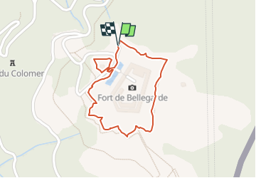
Randonnée Marche de 959 m à découvrir à Occitanie, Pyrénées-Orientales, Le Perthus. Cette randonnée est proposée par jopost.
Description
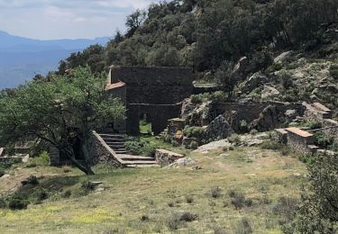
quand vous arrivez au Perthus, prenez la première à droite direction le fort de Bellegarde. si le fort est fermé, vous pouvez faire tout le tour, environ 950m. magnifique fort
Localisation
Pays :
France
Région :
Occitanie
Département/Province :
Pyrénées-Orientales
Commune :
Le Perthus
Localité :
Unknown
Départ:(Dec)
Départ:(UTM)
488389 ; 4700803 (31T) N.
Commentaires
Randonnées à proximité
![Randonnée Marche Les Cluses - LES CLUSES 66 - Photo](https://media.geolcdn.com/t/375/260/ext.jpg?maxdim=2&url=https%3A%2F%2Fstatic1.geolcdn.com%2Fsiteimages%2Fupload%2Ffiles%2F1553511878bg_sport_marche.png)
![Marche Marche](https://static1.geolcdn.com/sitytour/trail-icons/101.png)
LES CLUSES 66
Marche
Facile
(9)
Les Cluses,
Occitanie,
Pyrénées-Orientales,
France
![](/images/other/stat-length.png)
9,4 km | 12,8 km-effort
1h 50min
![](https://static1.geolcdn.com/siteimages/upload/files/16400158638029165_repeat_loop_refresh_sync_direction_icon.png)
Oui
![Randonnée Marche L'Albère - SAINT-JEAN-D'ALBERE 66 - PUIG de Sant Christau par le coll de Sant Joan - Photo](https://media.geolcdn.com/t/375/260/ext.jpg?maxdim=2&url=https%3A%2F%2Fservices.sitytrail.com%2FGeolivesWS%2FDownloadMedia.ashx%3FTrailID%3D452444%26Media%3D20150731170134.jpg)
![Marche Marche](https://static1.geolcdn.com/sitytour/trail-icons/101.png)
SAINT-JEAN-D'ALBERE 66 - PUIG de Sant Christau par le coll de Sant Joan
Marche
Difficile
(1)
L'Albère,
Occitanie,
Pyrénées-Orientales,
France
![](/images/other/stat-length.png)
10,1 km | 17 km-effort
2h 46min
![](https://static1.geolcdn.com/siteimages/upload/files/16400158638029165_repeat_loop_refresh_sync_direction_icon.png)
Oui
![Randonnée A pied la Jonquera - Marxa dels dòlmens i ruta dels estanys - Photo](https://media.geolcdn.com/t/375/260/ext.jpg?maxdim=2&url=https%3A%2F%2Fmedia.geolcdn.com%2Ff%2Ffedcbff4-20db-4413-b792-cfa0f34dafa2.jpeg)
![A pied A pied](https://static1.geolcdn.com/sitytour/trail-icons/100.png)
Marxa dels dòlmens i ruta dels estanys
A pied
Facile
la Jonquera,
Catalogne,
Gérone,
Espagne
![](/images/other/stat-length.png)
11,5 km | 14,5 km-effort
3h 17min
![](https://static1.geolcdn.com/siteimages/upload/files/16400158638029165_repeat_loop_refresh_sync_direction_icon.png)
Oui
![Randonnée A pied la Jonquera - PR-C 71 La Jonquera-Portbou - Photo](https://media.geolcdn.com/t/375/260/ext.jpg?maxdim=2&url=https%3A%2F%2Fmedia.geolcdn.com%2Ff%2F5e6d3380-2250-4b33-97db-8f0c01794288.jpeg)
![A pied A pied](https://static1.geolcdn.com/sitytour/trail-icons/100.png)
PR-C 71 La Jonquera-Portbou
A pied
Très difficile
la Jonquera,
Catalogne,
Gérone,
Espagne
![](/images/other/stat-length.png)
39 km | 68 km-effort
15h 26min
![](https://static1.geolcdn.com/siteimages/upload/files/16400158638029165_repeat_loop_refresh_sync_direction_icon.png)
Non
![Randonnée Marche Les Cluses - LES CLUSES 66 - LE PERTHUS - - Photo](https://media.geolcdn.com/t/375/260/ext.jpg?maxdim=2&url=https%3A%2F%2Fstatic1.geolcdn.com%2Fsiteimages%2Fupload%2Ffiles%2F1553511878bg_sport_marche.png)
![Marche Marche](https://static1.geolcdn.com/sitytour/trail-icons/101.png)
LES CLUSES 66 - LE PERTHUS -
Marche
Moyen
(2)
Les Cluses,
Occitanie,
Pyrénées-Orientales,
France
![](/images/other/stat-length.png)
14,4 km | 20 km-effort
2h 57min
![](https://static1.geolcdn.com/siteimages/upload/files/16400158638029165_repeat_loop_refresh_sync_direction_icon.png)
Oui
![Randonnée Marche Maureillas-las-Illas - RIUNOGUES PORTELL PANISSAR - Photo](https://media.geolcdn.com/t/375/260/ext.jpg?maxdim=2&url=https%3A%2F%2Fmedia.geolcdn.com%2Ff%2F4c8ab771-8eed-403d-8d61-1b30ad4c486f.jpg)
![Marche Marche](https://static1.geolcdn.com/sitytour/trail-icons/101.png)
RIUNOGUES PORTELL PANISSAR
Marche
Moyen
(1)
Maureillas-las-Illas,
Occitanie,
Pyrénées-Orientales,
France
![](/images/other/stat-length.png)
18 km | 26 km-effort
4h 35min
![](https://static1.geolcdn.com/siteimages/upload/files/16400158638029165_repeat_loop_refresh_sync_direction_icon.png)
Oui
![Randonnée Marche la Jonquera - 20230427 au départ du Perthus-crash DC6 1986 - Photo](https://media.geolcdn.com/t/375/260/ext.jpg?maxdim=2&url=https%3A%2F%2Fmedia.geolcdn.com%2Ff%2Fc1fe57ed-124b-4cbe-9732-771cc398fda1.jpg)
![Marche Marche](https://static1.geolcdn.com/sitytour/trail-icons/101.png)
20230427 au départ du Perthus-crash DC6 1986
Marche
Difficile
la Jonquera,
Catalogne,
Gérone,
Espagne
![](/images/other/stat-length.png)
13,9 km | 21 km-effort
3h 54min
![](https://static1.geolcdn.com/siteimages/upload/files/16400158638029165_repeat_loop_refresh_sync_direction_icon.png)
Oui
![Randonnée Marche Maureillas-las-Illas - Maureillas l’as illas - Photo](https://media.geolcdn.com/t/375/260/ext.jpg?maxdim=2&url=https%3A%2F%2Fmedia.geolcdn.com%2Ff%2F3991962e-e766-4b43-81bb-efcf417f6ad8.jpg)
![Marche Marche](https://static1.geolcdn.com/sitytour/trail-icons/101.png)
Maureillas l’as illas
Marche
Très facile
Maureillas-las-Illas,
Occitanie,
Pyrénées-Orientales,
France
![](/images/other/stat-length.png)
14,3 km | 19,7 km-effort
3h 46min
![](https://static1.geolcdn.com/siteimages/upload/files/16400158638029165_repeat_loop_refresh_sync_direction_icon.png)
Oui
![Randonnée Marche Maureillas-las-Illas - Riunogues - Photo](https://media.geolcdn.com/t/375/260/ext.jpg?maxdim=2&url=https%3A%2F%2Fmedia.geolcdn.com%2Ff%2F64762b4f-e33f-4bab-86e8-9a90f885caee.jpg)
![Marche Marche](https://static1.geolcdn.com/sitytour/trail-icons/101.png)
Riunogues
Marche
Maureillas-las-Illas,
Occitanie,
Pyrénées-Orientales,
France
![](/images/other/stat-length.png)
11,1 km | 16,4 km-effort
2h 49min
![](https://static1.geolcdn.com/siteimages/upload/files/16400158638029165_repeat_loop_refresh_sync_direction_icon.png)
Oui